


As part of River Deep Mountain AI, we are now releasing an early version of our Open Flow Model on GitHub. Our model can help fill in current gaps in river flow data using artificial intelligence.
Understanding river flow is essential for effective catchment and river management. Flow data, typically measured in cubic meters per second (m³/s), describe the volume of water moving past a location on a river at a given time. This information is critical for predicting floods, identifying and tracing pollution sources, and managing ecosystems and water quality. However, flow data are often sparse or entirely missing, especially in smaller or remote rivers. This is largely due to the high cost of installing and maintaining monitoring stations, leaving many catchments ungauged and without direct observations.
Catchment managers and regulators often rely on surrogate data from comparable catchments, existing paid-for datasets or conduct expensive monitoring campaigns. While these approaches can be useful, they are limited in scalability and timeliness, especially when rapid or wide-scale assessments are needed.
To overcome this challenge, we have developed a Long Short-Term Memory (LSTM) model based on a recurring neural network (RNN) architecture that integrates static and dynamic data sources to estimate daily mean river flow, without the need to install a flow-gauge. Our Open Flow Model can be used as an additional support-tool for decision-makers to get a faster and cheaper understanding of river characteristics.
Using more than 40 years of daily river flow data for England
To ensure transferability between rivers and catchments, we have intentionally focused our model development on open source datasets with national coverage, ensuring the development of a robust and general model for predicting river flow across England.
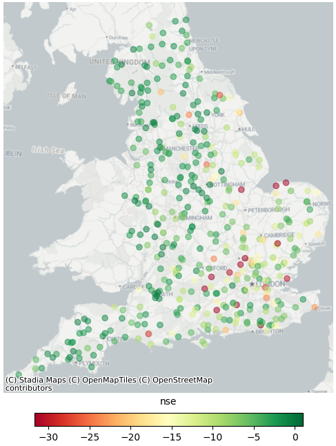
Our flow prediction model compiles historical flow, weather and catchment data from the CAMELS-GB dataset, the Environment Agency’s Hydrology Data Explorer, and a curated list of chalk streams from Natural England. This includes 40 years of daily river flow data from 409 catchments across England, enabling our model to understand the relationship between weather, topography, catchment attributes and river flow.