Skip to main content Skip to footer
  • "com.cts.aem.core.models.NavigationItem@2e77078f" Careers
  • "com.cts.aem.core.models.NavigationItem@6d89031c" News
  • "com.cts.aem.core.models.NavigationItem@1c2d49d6" Events
  • "com.cts.aem.core.models.NavigationItem@70ea67c5" Investors
Cognizant Blog

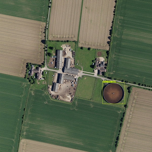
As part of River Deep Mountain AI, we are releasing the latest version of our remote-sensing model capable of detecting above-ground, circular slurry tanks. Slurry tanks are important as they represent potential sources of diffuse agricultural pollution in river catchments. In England, agriculture is one of many sources of pollution impacting water quality. For instance, around 60% of nitrate, 25% of phosphorus and 75% of sediment in water bodies is estimated to originate from agriculture[1]. These pollutants, together with others, contribute to only 14% of water bodies in England meeting the good ecological status’ defined by the Water Framework Directive.

When assessing the pollution risk of a river catchment, it’s often necessary to do walkovers next to the river to detect areas with increased run-off (diffuse pollution) risks. These walkovers are time-consuming, inefficient and ideally need to be undertaken during wet weather to give an accurate understanding of potential pollution risks.

To try and help reduce the financial costs associated with time-consuming walkovers, we are developing several remote sensing-based models utilising computer vision and satellite imagery to detect potential sources of pollution. Now, we are releasing the first of these models, focused on detecting circular slurry tanks.

The models will enable catchment managers and other stakeholders to quickly pinpoint some of the potential sources of pollution within a catchment for targeted investigations.

Developing a novel dataset of slurry tanks

Slurry tanks are critical livestock farming infrastructures constructed to store animal waste in the form of liquid and sludge. Leakage from these structures can pose risks of contamination of water, soil and air. The high volumes of phosphorus-based and nitrogen-based compounds present in slurry tanks represent a pollution risk that can lead to contamination and eutrophication of groundwater and surface waters. The pathogens present in slurry tanks also represent a risk to drinking water abstraction points and public bathing water sites.

Detecting slurry tanks from satellite imagery has become increasingly feasible at scale with the rise of remote sensing and artificial intelligence. AI object detection models that can scan imagery for specific features in near real-time enables large-scale environmental monitoring.


farm

Image: Our slurry tank detection model currently have a precision of 94.5% , recall of 77.8%, and an average precision of 88.3%. 


We have deployed YOLO (You Only Look Once), a popular algorithm used for object detection tasks. Unlike traditional methods, this model transforms object detection into a single-pass prediction task, making the process both fast and efficient.

Our model was trained on aerial imagery from known locations of slurry tanks in England, Wales and Denmark. Images were adjusted for brightness, contrast, and hue to simulate different lighting angles, noise and other real-world variations. Mosaics of the images were produced to improve the model performance, especially for detecting small objects and in diverse contexts. Our training process leveraged YOLOv8 with an AdamW optimiser considering seven additional classes of above-ground storage tanks, building upon existing academic work[2]. This reduces overfitting through more effective weight regularisation and allows for identification of real-world objects.

The model provides image identification and adds geographic intelligence by linking detections to spatial coordinates. This allows for the precise geo-location identification of slurry tanks, supporting management and environmental protection actions that focus on reducing the environmental risk and potential impacts caused by leaking slurry tanks.

Since the first release of our model (in June 2025), it has undergone extensive validation to confirm that the accuracy seen in the initial development also applies to new, unseen catchments. For this purpose, two complementary validation strategies was chosen; augmentation based and geographic generalisation.

For the augmentation-based validation, we augmented the original 270 annotated images of slurry tanks to evaluate the model’s robustness under varying image conditions. The augmentations included flipping the images, changing the brightness and contrast, adding noise and blur or reducing the image quality. The model showed a strong performance under these conditions, with an average precision of 93.7%, and recall of 80.8%.

The geographical generalisation validation approach was undertaken to test how well the model performs on unseen geographic locations and images. Using 233 images, containing 7 different instance categories (farmyard with slurry tank, farmyard without slurry tanks, circular objects outside farmyards, etc.), we tested the model’s ability to detect slurry tanks correctly and its tendency to misidentify other objects as slurry tanks. Compared to the augmentation-based validation, the model showed a

lower precision of 71%, but an increased recall of 98.3%. This means that the model has a slight tendency to detect false positives (particularly when faced with visually similar circular structures) but is very unlikely to miss a slurry tank. In our opinion, this trade-off will be acceptable in many real-life scenarios, as it ensures that very few slurry tanks are missed, and any false positives can be managed through manual reviews.

A collaborative and open-sourced approach

The overarching objective of River Deep Mountain AI is to bring key stakeholders involved in waterbody health together and collaboratively develop open-source AI/ML models that can inform effective actions to tackle waterbody pollution. 

To democratise artificial intelligence in the water sector, all our models will be released open source to benefit the entire sector.

River Deep Mountain AI is funded by the Ofwat Innovation Fund and consists of 6 core partners: Northumbrian Water, Cognizant Ocean, Xylem Inc, Water Research Centre Limited, The Rivers Trust and ADAS. The project is further supported by 6 water companies across the United Kingdom.

[1] White, P. J., & Hammond, J. P. (2009). The sources of phosphorus in the waters of Great Britain. Journal of environmental quality38(1), 13-26.

Collins, A. L., & Anthony, S. G. (2008). Assessing the likelihood of catchments across England and Wales meeting ‘good ecological status’ due to sediment contributions from agricultural sources. environmental science & policy11(2), 163-170.

[2] Robinson, C., Bradbury, K. & Borsuk, M.E. Remotely sensed above-ground storage tank dataset for object detection and infrastructure assessment. Sci Data 11, 67 (2024).


Cognizant Nordics

Our experts are contributing with exciting insights about what is going on within technology and innovation.


Latest posts
Related posts