


As part of River Deep Mountain AI, we are now releasing a remote-sensing model capable of detecting poached land. Poached land is typically defined as ‘the physical breakdown of soil caused by the trampling of livestock’, resulting in soil compaction, vegetation loss, and increased erosion and runoff. However, for the development of this model, the term poaching was regarded as an all-encompassing word to describe disturbed ground (a potential source of diffuse water pollution), which could be caused by livestock or other activities such as rutting from farm vehicles.
Poached land and areas of soil degradation are important as they represent potential sources of diffuse agricultural pollution in river catchments. In England, diffuse pollution from agriculture significantly impacts water quality. For instance, around 70% of nitrates and 25% of phosphorus in water bodies are estimated to originate from farming activities. Additionally, it is believed that 75% of sediments in water bodies are derived from agricultural practices. Agricultural diffuse pollution contributes to 86% of water bodies in England not meeting ‘good ecological status’ as defined by the Water Framework Directive.
When assessing the diffuse pollution risk of a river catchment, it’s often necessary to do walkovers next to the river to detect areas with increased run-off risks. These walkovers are time-consuming and often require wet weather to give an accurate understanding of potential impact.
To address this challenge, we have developed a suite of remote sensing-based models utilising computer vision and satellite imagery to detect bare cropland, slurry tanks and poached fields.
These models enable catchment managers and other stakeholders to quickly pinpoint potential sources of diffuse pollution within a catchment, further facilitating targeted investigations.
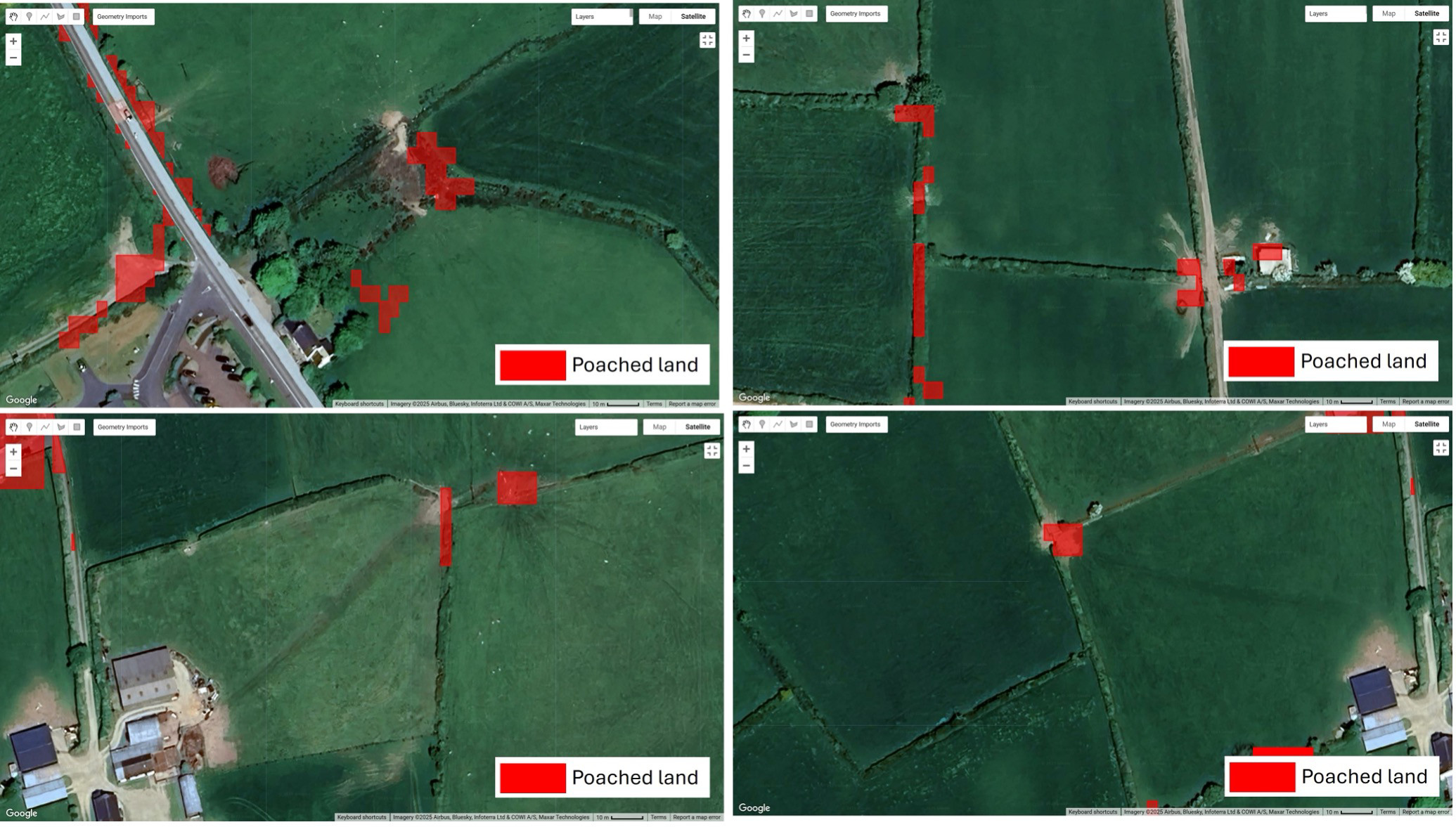
Detecting poached land
Poached land refers to areas of soil that have been compacted and degraded due to repeated trampling by livestock, particularly under wet conditions. Machinery use can also lead to rutting, especially on parts of fields experiencing more farm machinery traffic, such as near gateways. Both activities reduce water infiltration and reduce crop growth, resulting in increased surface runoff. The environmental consequences are potentially substantial, including erosion, water pollution, and increased flood risk.
At 10-m spatial resolution, fine details in standard Sentinel-2 imagery are often blurred, making it hard to separate poached areas from the surrounding features. To overcome this, we turned to Sentinel-2 Deep Resolution 3 (S2DR3), a super-resolution product that enhances the original Sentinel-2 data to an impressive 1-m spatial resolution using advanced AI-driven upscaling. This finer detail allows us to ascertain the texture, shape, and spatial context of degraded patches that would otherwise vanish into a single, mixed pixel. We utilised all 10 spectral bands available in S2DR3, ranging from visible (blue, green, red) to red edge, near-infrared (NIR), and short-wave infrared (SWIR), to capture both visible and non-visible indicators of landcover change.
At its core, our model has a random forest classifier, which has been trained on manually digitised polygons across five land cover classes: poached land, bare cropland, cropland, trees, and waterbodies. This multi-class approach helped reduce spectral confusion, particularly between poached and bare cropland.
To further refine the classification, we implemented a multi-stage filtering process:
- Masking of built-up areas using the Dynamic World dataset (Google & WRI) to exclude impervious surfaces.
- Connected-pixel filtering to remove isolated or noisy detections, retaining only spatially coherent features.
- Minimum area thresholds to ensure only meaningful patches were preserved.
- Spectral index filtering using Bare Soil Index (BSI) and Normalized Difference Vegetation Index (NDVI) from standard Sentinel-2 Level-2A imagery to exclude large bare soil areas and vegetated regions, respectively.
- Masking of the road network using OpenStreetMap data to exclude road and track surfaces.
Each stage of this workflow incrementally reduced false positives, resulting in a robust and interpretable map of likely poached areas.