February 12, 2026
WhaleAgent: Agentic AI to Reduce Vessel-Whale Collisions at Global Scale

WhaleAgent: Agentic AI to Reduce Vessel Whale Collisions at Global Scale
An open, agentic AI project combining ocean, satellite, and vessel data to help volunteers and partners predict and prevent whale–vessel collisions at scale.
Every year, an estimated 20,000 whales are killed by vessel strikes. For large whale species, ship collisions are now one of the leading causes of death. This is not a marginal problem affecting isolated regions. Global shipping routes overlap with roughly 92 percent of known whale habitats, while fewer than 7 percent of high-risk areas have any form of protective measures in place.
At the same time, maritime traffic is increasing. Global shipping volumes are projected to triple by 2050. Without new approaches, the likelihood of vessel–whale collisions will rise sharply, further endangering whale species with only a few hundred individuals remaining and increasing operational and safety risks for the maritime industry.
The challenge is not a lack of concern or intent. It is a lack of integrated, actionable intelligence that becomes available early enough to inform real decisions.
Why current approaches are falling short
Most efforts to reduce whale strikes rely on static interventions. These include fixed speed reduction zones, seasonal advisories, and post-incident analysis of collision hotspots. While speed reduction has proven effective in some regions, reducing whale mortality by up to 13 percent, these measures assume that risk is stable and predictable.
In reality, it is not.
Whales shift routes and timing with migration patterns, seasonality, ocean temperature, prey, and food availability. Vessel risk shifts with traffic density, routing changes, speed, and schedule pressure. The result is a constantly changing overlap problem that current systems do not model well.
This is where the practical barriers show up. Labeled whale data is sparse. Environmental and vessel traffic data arrive at different cadences and formats. Satellite imagery can help but is intermittent and affected by clouds, glare, and latency. Put simply, the challenge is integrating the right signals quickly enough to inform real decisions, and most systems stop at detection or retrospective reporting.
Introducing WhaleAgent: built for prediction and proactive actions
WhaleAgent is a project proposal built in direct response to this gap.
Instead of focusing on detecting whales after vessels have already entered high-risk areas, the project asks a different question: how can we estimate where vessel–whale collision risk is increasing early enough for operators to act?
WhaleAgent approaches this by combining multiple signals into a single, continuously updated view of risk. At the center of the project is an AI Agent-Orchestrated Risk Map, which integrates learned spatio-temporal patterns, environmental conditions, and available imagery to assign probabilistic risk scores to specific ocean regions.
The intent is straightforward: provide dynamic, location-specific intelligence so preventative actions, such as speed reduction or course adjustment, can happen before a vessel enters those areas.
How the AI Agent-Orchestrated Risk Map works
WhaleAgent coordinates multiple model layers through AI agents, each contributing a different dimension of risk.
A spatio-temporal predictive layer learns historical patterns and seasonal trends in whale presence and vessel concentration. Using inputs such as whale habitat maps, vessel traffic data, and ocean conditions, it estimates the probability of overlap in a given area.
An environmental layer incorporates satellite-derived sea surface temperature data, including sources such as MODIS and Sentinel-3. These signals help identify conditions associated with whale presence and refine risk estimates across daily, weekly, and seasonal patterns.
Where available, a satellite image layer ingests whale-annotated imagery to further improve model performance and refine the risk map.
Together, these layers allow the system to update collision risk as ocean and traffic conditions change, providing earlier warnings than static zones or detection-only systems.

Figure 1: High-level Agentic AI Architecture. The AI agents learn the complex patterns from diverse historical, near real-time, and real-time data sources and projects the probability of whale-vessel collision over a dynamic risk map.
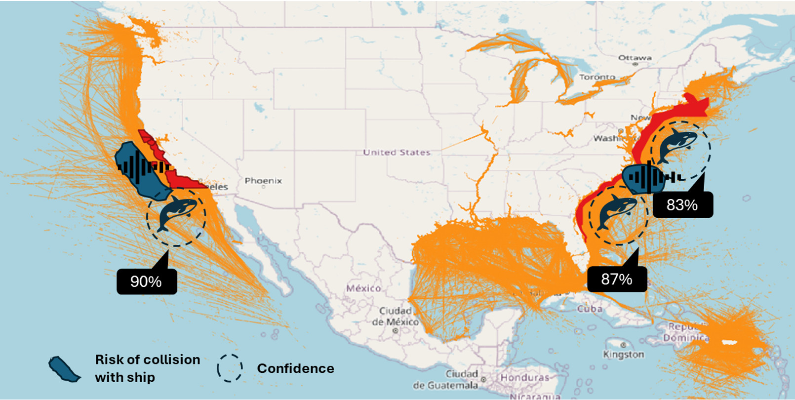
Figure 2: AI agent orchestrated dynamic whale collision risk map
What WhaleAgent is designed to deliver
WhaleAgent is designed to produce decision-relevant outputs that can be used in real operational contexts, rather than static reports or after-the-fact analysis:
A dynamic risk map highlighting potential vessel–whale interaction zones across wide ocean regions, updated as environmental and traffic conditions change
Quantified collision likelihood based on learned spatio-temporal patterns, seasonality, and co-location probability between whales and vessels
Timely warnings and recommendations intended to support proactive mitigation actions such as speed reduction, course adjustment, or increased situational awareness in higher-risk areas
This risk intelligence is intended to inform human decision-making, not replace it. In practice, whale collision risk cannot be treated independently from the other constraints vessel operators manage every day, including fuel consumption, weather conditions, safety considerations, and schedule pressures.
By providing earlier, location-specific risk signals, WhaleAgent is designed to complement the tools and workflows captains already use onboard. Over time, this could support more dynamic and informed routing and operational decisions, with whale collision risk considered alongside other real-time factors, rather than addressed through fixed zones or isolated alerts.
With approximately 20,000 whales lost annually to vessel strikes, even incremental improvements in prediction and avoidance can have meaningful impact. Based on proposal assumptions, WhaleAgent estimates the potential to support conservation of roughly 6,000 whales per year. Using the Return on Lives framework, this corresponds to a standardized estimate of 12,000 lives supported per $1 million invested.
A collaborative effort
WhaleAgent has been developed with the understanding that no single dataset, model, or organization can solve this problem alone. The project brings together contributions across AI research, ocean and environmental data, and maritime operations, with partners helping shape the technical approach and validate it against real operational contexts.
Call for volunteers
This project is an open, collaborative initiative, and its next phase depends on community participation.
WhaleAgent is being developed through Project Resilience, a collaborative initiative aligned with the United Nations Sustainable Development Goals and focused on building shared, public AI tools to address large-scale global challenges. Through this effort, contributors can engage directly with the WhaleAgent codebase and help shape how the project evolves.
We welcome contributors with experience aligned to the core project scope, including researchers and practitioners working in AI and machine learning, spatio-temporal and geospatial modeling, satellite-derived environmental data, and the integration of vessel traffic and ocean datasets. Contributions at this stage may involve shaping the models, refining risk metrics, identifying available data sources and solutions, strengthening the system’s real-world applicability, or exploring potential partnerships.
If you are interested in contributing data, expertise, or technical capability to WhaleAgent, we invite you to get involved and help turn predictive intelligence into measurable conservation outcomes.

Stig Martin Fiskå is the Global Head of AI for Good at Cognizant, leveraging cutting-edge technologies and innovative solutions to drive sustainability, efficiency, and growth.